
Pre-Construction
SITE SELECTION
Make informed decisions early with clear, high-resolution aerial data that provides a complete understanding of the property and its surroundings. We capture current site conditions and context to support acquisition, feasibility, and early-stage planning.
Commonly used in:
Land acquisition, due diligence, feasibility studies, and early-stage development planning.

Establish a documented visual record of site conditions before construction begins to protect your team from disputes and liability. Our deliverables create a clear, time-stamped baseline that can be referenced throughout the project lifecycle.
Commonly used in:
Pre-construction documentation, risk management, claims support, and stakeholder protection.

ZONING MEETINGS
Bring clarity to the approval process with professional aerial visuals that clearly communicate site conditions, context, and project intent. We help you present your project effectively to boards, stakeholders, and the public.
Commonly used in:
Zoning board meetings, planning approvals, permitting processes, and public hearings

Pre-Construction
Establish site baseline and planning clarity before work begins
Services
Common challenges before construction begins
-
Lack of clear existing conditions
-
Difficulty communicating site context
-
Limited visibility into site constraints
Typical deliverables
-
Orthomosaic site maps
-
Existing conditions documentation
-
Annotated site imagery
-
Site context visuals for planning
SIte Selection
-
Get the most updated view of the property
-
Document existing site conditions
-
Include PDF of survey data in the contract for a comprehensive overview
We provide drone photography and video that clearly show the site context and surroundings.
Typical deliverables
-
Aerial overview photos
-
Short site context videos
Legal Protection
Capture a baseline map of the site and surrounding areas with time-stamped documentation. This provides a clear record of existing conditions, helping protect your team from disputes and unnecessary liability.
Site Context for Planning & Coordination
Provide clear, high-level visibility into site conditions to support planning discussions, stakeholder alignment, and early decision-making.
Typical deliverables
-
High-resolution inspection imagery
-
Annotated photos or video

Limited access to roofs and structures
We perform aerial inspections to capture detailed visuals without physical access.
Typical deliverables
-
High-resolution inspection imagery
-
Annotated photos or video

Progress Monitoring

Track Change Over Time with Visual Comparisons
Compare site conditions across multiple dates to clearly see progress, identify issues, and verify completed work. With side-by-side and overlay views, teams gain instant visibility into what’s changed—without needing to be on-site.
Why it matters:
-
Validate progress and milestones
-
Reduce disputes with time-stamped visual records
-
Improve communication with clear, visual updates
-
Make faster decisions with real-time context

Verified Material Value with Drone Measurement
On a recent project, we measured over 412 cubic yards of crushed stone, representing more than $20,000 in material value.
By validating actual quantities on-site, we helped eliminate uncertainty and ensured accurate billing.
Why this matters:
-
Even a 5–10% discrepancy can result in $1,000–$3,000+ in overcharges
-
Accurate measurements provide clear documentation for contractors and suppliers
-
Teams gain confidence knowing they are only paying for what was delivered
Construction
Progress Photos & Video
Progress Documentation
We conduct repeat flights from consistent locations to document progress over time.
Capture your jobsite on a weekly or bi-weekly basis to create a consistent visual record of progress across all phases of construction. Maintain a timestamped history that supports reporting, coordination, and accountability.
Commonly used in:
Progress reports, OAC meetings, pay applications, stakeholder updates, and project documentation.

Mapping & Earthwork Analysis
Track site changes with accurate, repeatable mapping that allows teams to measure earthwork quantities and compare progress over time. Gain visibility into grading activity and validate work completed.
Commonly used in:
Earthwork tracking, quantity verification, grading analysis, and schedule validation

Site Plan Overlays
Plan vs. Reality Verification
Overlay design plans directly onto real-world site conditions to compare what’s built against what’s planned. Identify conflicts early and ensure alignment between design, field execution, and coordination teams.
Commonly used in:
VDC coordination, QA/QC, trade coordination, and conflict detection

Construction
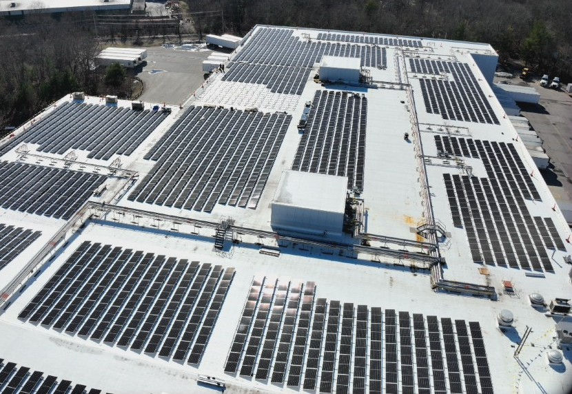
Roofing & Facade
Roofing & Exterior Inspection
Monitor roofing systems and building exteriors to verify installation quality and identify potential issues early. Capture detailed visuals that support inspection, coordination, and long-term performance.
Commonly used in:
Roofing inspections, facade verification, waterproofing checks, and exterior QA/QC
Construction
Stockpile Volumetrics
Stockpile & Material Tracking
Measure stockpiles quickly and accurately to understand material quantities on site. Replace manual estimates with data-driven measurements that support planning, logistics, and cost control.
Commonly used in:
Material tracking, trucking estimates, inventory management, and cost verification
Concrete & Foundation Verification
Document pre-pour and post-pour conditions to ensure critical elements are installed correctly before they are permanently covered. Validate layout, penetrations, and embedded components with visual records.
Commonly used in:
Pre-pour inspections, QC documentation, VDC coordination, and issue resolution
Steel Structure
Structural Progress Tracking
Track the installation of structural steel and decking with consistent aerial captures that provide a clear view of sequencing, progress, and completed work. Maintain a record of structural elements before they are enclosed.
Commonly used in:
Schedule tracking, quantity verification, structural coordination, and progress validation
Construction
Services

Progress is hard to track consistently
We conduct repeat flights from consistent locations to document progress over time.
Typical deliverables
-
Progress photo sets
-
Side-by-side time comparisons
-
Short progress videos
Site changes are difficult to visualize
We use photogrammetry to visualize site changes, surfaces, and material movement.
Typical deliverables
-
Orthomosaic updates
-
Surface and volume visuals


Access limits ongoing inspections
We capture aerial inspection imagery without interrupting site activity.
Typical deliverables
-
Inspection photo and video sets
Teams struggle to stay aligned
We provide a shared, objective aerial view everyone can reference.
Typical deliverables
-
Shared image libraries
-
Maps and visuals used across teams


Track Change Over Time with Visual Comparisons

Post Construction
Final Project Tours & Marketing
Final Project Showcase
Capture your completed project with high-quality aerial and interior visuals that highlight design, craftsmanship, and overall execution. Deliver marketing-ready content that supports leasing, sales, and portfolio promotion.
Commonly used in:
Project closeouts, leasing campaigns, sales listings, portfolio marketing, and client handover

Construction Time-Lapse
Create a compelling visual story of your project from start to finish. Time-lapse videos showcase progress, milestones, and transformation, making them ideal for stakeholders, marketing, and brand positioning.
Commonly used in:
Client presentations, investor updates, social media, company marketing, and project recaps

3D Digital Twin (As-Built)
As-Built Digital Twin
Deliver a complete 3D model of the finished project that serves as a long-term reference for operations, maintenance, and future planning. Provide owners and facility teams with a detailed, accessible record of the built environment.
Commonly used in:
Facility management, asset documentation, maintenance planning, and long-term property management

Post-Construction
Services
No clear record of completed conditions
We capture final aerial documentation and mapping for closeout.
Typical deliverables
-
Final aerial photo sets
-
Post-construction orthomosaics
We deliver commercial drone photography and videography tailored for communication.
Typical deliverables
-
Curated photo libraries
-
Edited aerial videos
Building condition issues need follow-up
We conduct visual and thermal aerial imaging to support post-construction review.
Typical deliverables
-
Inspection imagery
-
2D thermal maps
-
Annotated visuals
We also Provide
Digital Surface Models (DSM)
Ground and surface elevation data for cut/fill analysis, volume calculations, and terrain modeling.
Custom Panoramics
360° site views for presentations, stakeholder updates, and immersive site documentation.
360's in all Cardinal Directions
North, South, East, West panoramic documentation for complete site context.
Aerial Photos & Video
Marketing-ready imagery for web, print, social media, proposals, and brochures.
Orthomosaic Maps
Georeferenced 2D maps with measurements for planning, verification, and reporting.
And Much More!
Thermal imaging, 3D point clouds, and tailored deliverables for your project needs.
How Bay State Drones supports every phase
Professional Execution. Reliable Results.
Every project is planned and executed by an FAA Part 107 certified remote pilot, delivering accurate, decision-ready aerial data your team can rely on from pre-construction through project closeout.
We don’t just capture visuals, we provide clear, consistent data that supports planning, coordination, and confident decision-making across your entire project lifecycle.


Construction Pictures
A look at recent construction and site work.
© 2026 Bay State Drones. All Rights Reserved. Project by Responsab.
Business Info
-
DUNS Number: 081118021
-
NAICS Code: 541370, 541922, 541330, 541990
-
FAA Part 107: 4091385
-
Certified Veteran-Owned Small Business (VOSB)
-
Massachusetts Supplier Diversity Office (VBE)