
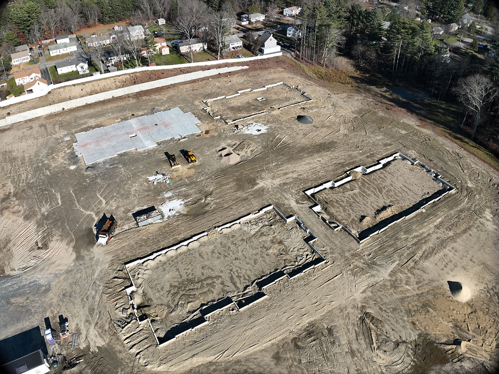
Consistent aerial capture that gives your team a clear, reliable visual record of site conditions to track progress and keep stakeholders aligned.
When teams use this: Ideal for active projects that need clear documentation, progress visibility, and stakeholder communication.
Commonly used in: Construction
Deliverables include orthomosaics, progress photo sets, and executive ready reporting that keeps every team aligned.
-
Progress reports with annotated call outs
-
Timeline comparisons and milestone tracking
-
Site safe documentation for owners and sub contractors
-
Weekly or biweekly reporting cadences


Transform drone data into accurate orthomosaics, 3D models, and measurements that support planning, verification, and coordination.
Commonly used in: Projects that require accurate site data for planning, quantity tracking, or verification.
-
Orthomosaic maps
-
3D site models
-
Cut/fill and measurement data
-
Exportable files for BIM and project platforms
Recurring drone capture and structured reporting that provide continuous visibility across your project lifecycle.
When teams use this: Projects that need consistent updates, risk reduction, and stakeholder alignment over time.
Commonly used in: Construction
Premium aerial photography, video, and site overviews that help listings stand out and close faster.
-
Scheduled flight programs
-
Progress reports and dashboards
-
Timeline comparisons
-
Shareable project updates

We capture high-resolution aerial data to give you a complete, real-world view of your site, without disrupting operations.
Commonly used in:
Commercial real estate, facilities management, construction closeouts, and infrastructure inspections.
Deliverables include thermal reports, annotated imagery, and inspection summaries designed for clear communication and decision-making:
-
Aerial photo and video documentation
-
2D Orthomosaic mapping and site baselines
-
3D data capture for digital twin creation
-
360° site walkthroughs
-
RTK enabled precision mapping for consistent accuracy


We turn raw aerial data into actionable insights that help you identify issues early and make informed decisions.
Commonly used in:
Building envelope inspections, roofing systems, solar and energy audits, infrastructure assessments, and preventative maintenance programs.
-
Thermal inspections for heat loss, moisture, and electrical issues
-
Structural and façade assessments
-
Roof inspections and condition monitoring
-
Progress verification and quality control
-
Site risk identification and safety awareness
We deliver clear, professional outputs that keep your entire team aligned and your project moving forward.
Commonly used in:
Construction progress tracking, asset lifecycle management, capital planning, facility operations, and stakeholder reporting across commercial and infrastructure projects.
-
Annotated inspection reports
-
Progress tracking over time (compare datasets)
-
Volume calculations and site analytics
-
Shareable cloud-based project access
-
Ongoing monitoring for long-term projects
Set the stage before a property hits the market with clear, professional aerial visuals that highlight location, access, and surrounding context. This early positioning helps generate interest, support investor outreach, and ensure your property stands out from day one.
Commonly used in:Pre-market listings, broker pitches, investor outreach, site evaluations, and development planning.
-
Drone overview of the property and surrounding area
-
Neighborhood context and nearby amenities
-
Lot lines, land features, and access points
-
Visuals for pre-market listings and investor outreach


Capture attention and drive more qualified buyers with high-quality aerial imagery and video optimized for listings and digital marketing. Professional visuals increase engagement, improve visibility, and help buyers quickly understand the full value of the property.
Commonly used in: MLS listings, online marketing campaigns, broker listings, leasing promotions, and social media advertising.
-
MLS-ready drone photos and video
-
High-resolution images for residential and luxury listings
-
Twilight and sunset shoots for premium presentation
-
Short-form video content for social and digital marketing
Showcase the full potential of commercial assets with visuals that highlight scale, location, and investment value. From active developments to stabilized properties, we provide content that supports leasing, sales, and investor communication.
Commonly used in: Development marketing, leasing campaigns, investor presentations, portfolio marketing, and capital raises.
-
Office, retail, and mixed-use property visuals
-
Site highlights including parking, access, and traffic flow
-
Surrounding infrastructure and business proximity
-
Marketing assets for leasing, sales, and investor presentations

Professional aerial visuals that elevate your listings and help communicate value quickly and clearly to buyers, tenants, and investors.
When teams use this:
Ideal for brokers, developers, and property managers who need standout marketing assets, clear site context, and visuals that support faster leasing and sales.
Commonly used in:
Commercial real estate, industrial properties, retail centers, office buildings, and land development
Deliverables include high-quality drone visuals and marketing-ready assets designed to support listing performance and stakeholder communication:
-
MLS-ready aerial photo packages
-
Cinematic property videos (30–90 seconds)
-
Neighborhood and amenity context visuals
-
Branded marketing assets for presentations
-
Updated visuals for leasing or development phases

What We Deliver Across Your Project Lifecycle
Actionable drone data designed to support real construction decisions
High-resolution aerial capture
Orthomosaic mapping
Digital Terrain Models
Progress photo documentation
3D reality capture
Stakeholder reporting
Timeline Comparisons
Volumetric measurements
Photos & Video for Social Media
© 2026 Bay State Drones. All Rights Reserved. Project by Responsab.
Business Info
-
DUNS Number: 081118021
-
NAICS Code: 541370, 541922, 541330, 541990
-
FAA Part 107: 4091385
-
Certified Veteran-Owned Small Business (VOSB)
-
Massachusetts Supplier Diversity Office (VBE)